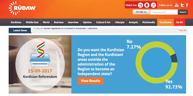
On September 25th 2017 the Kurdish Regional Government (KRG) in the Kurdistan Autonomous Region of Iraq (KR-I) held a referendum to vote for or against an independent state.
The Iraqi government declared the referendum unconstitutional and in reaction closed the airspace over the KR-I for all international civilian flights towards Erbil and Sulaymania.
Yet it can not be foreseen when or if this situation will change in the next months. My approach will for now consequently evolve in two separate directions.
On the one hand the theoretic research will take into account the works:
Zeynep N. Kaya – ‚Maps into Nations: Kurdistan, Kurdish Nationalism and International Society’ ( etheses.lse.ac.uk/645/1/Zeynep_Maps_into_Nations.pdf )
Sabrina Frutig – ‚Past and Present: The Interrelation of Displacement and State-Building in Iraq and Iraqi Kurdistan’
Layla M. Raswol – ‚Informelle Siedlungen in Arbil, Irak: Entstehung, Struktur, Potenziale‘
The results of the theoretic research will enable me to (re)evaluate the photographs taken for the project between 2014-2017.
Simultaneously I will follow the current conflict on ‚disputed areas’ claimed both by the KRG and the Iraqi Government after the defeat of the ‚Islamic State’ in Iraq. I will point out significant symbols and visual narratives that are used in the media coverage to strengthen national claims in- and outside the KR-I. Eventually I will create a series of Images located in the threshold of desired and constituted territory.